
Expedition
by Nate Hathaway

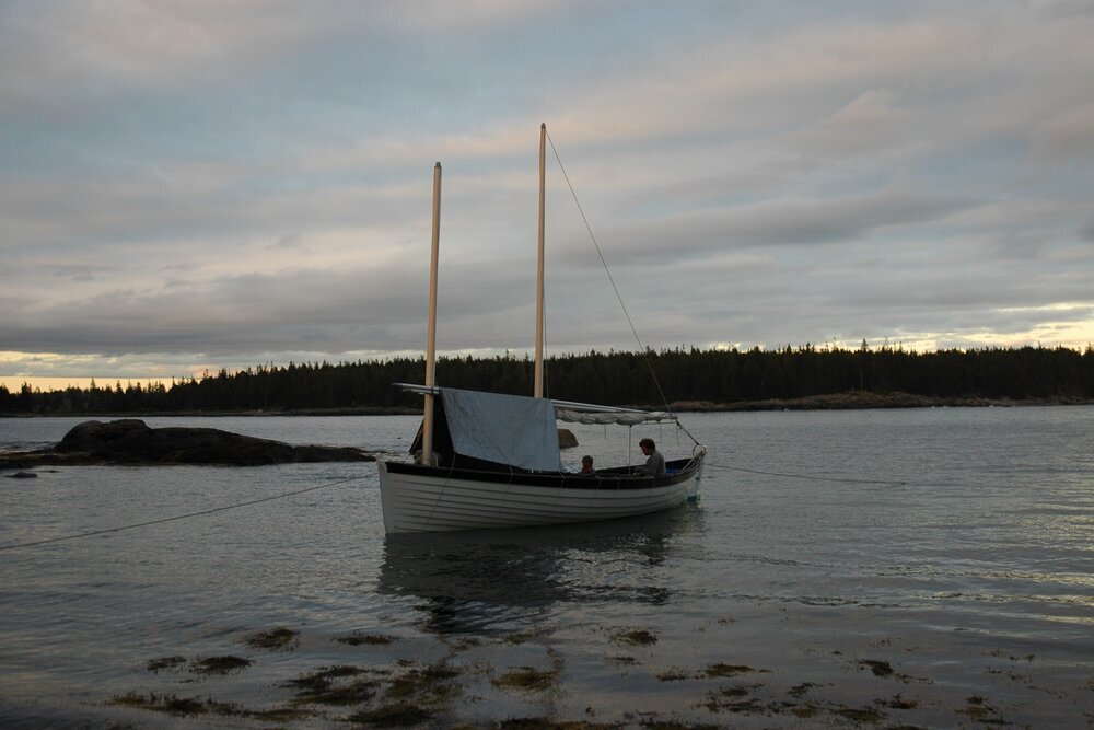
It was sailing distilled – the only instruments were a few handheld compasses, a dated, numbers-only black and white display handheld GPS, and our trusty bin of charts and chart tools. We had ourselves, our sea bags for the week, and a few tarps to keep the water out and some warmth in. There were two buckets up forward as a ‘head’ and a camp stove adapted to a propane tank for a galley. No engine, no bulkheads, you get the idea.

We left Rockland Wednesday morning with clear skies, heading easterly in a somewhat fluky 5-10 knot breeze. By mid-afternoon we had already passed half a dozen stunning islands around Vinalhaven before pulling up the board and snagging a vacant mooring behind a picturesque island lighthouse near Hurricane Island. It’s hard to believe how empty the bay was, given temps in the 60s and beautiful fall colors just starting to erupt in pockets of maples and birches. But that’s where sailing is these days if you don’t own a yacht, work on a boat, or have access through a niche boatbuilding school (lucky for us!); but we did have to share the island with mosquitoes.
After setting the stern hook we rowed in for a little shore exploration and set the bow hook on the beach. It turns out that bringing my waders was a good idea when ‘hauling back’ the now underwater bow anchor on the beach in the morning in a flooding tide. In the morning sun, schools of menhaden were pulsing just close enough to the surface for us to be dazzled by the gleaming parade of fins, a reminder of the bounty that still exists and has drawn so many to harvest the riches of the Gulf of Maine.
Trusting our NOAA marine forecast, we took off on a typical Sou’wester and broad-reached up to Stonington. As we approached, we passed the screeching quarry which kept so many schooners and islanders employed in the days of yore. It was a nice rip past islands and ledges aplenty, mostly relying on visual piloting and keeping a running conversation of ‘what island does that look like now?’, interspersed with a conclusive buoy now and again. We joked about how many ‘Maine-points’ you could earn for images with things like: lighthouses, schooners, idyllic coastal towns, wildlife, lobster boats, etc. I must’ve maxed out with a shot of the windjammer Angelique and another distant schooner as a lobster boat passed in front of us, waking lobster pots and catching a snip of mast and coiled halyard in the foreground.

One of our new apprentices, Kyle, sailed the boat right onto the public dock after only starting the program a week prior, in 15-20 knots with little room for error or maneuvering around the prominent rock features and wharves of Stonington. We snickered when a recently anchored windjammer crew came ashore and inquired how we got into the tight spot, wondering if we had an engine, despite the open boat lying before them.
2 hours later, we had seen Stonington and filled up on coffee. With 6 hours of daylight to spare in the late September sky, we ambitiously set off to land at Valley Cove in the fjord of Somes Sound, on Mount Desert Island. The Sou’wester held and we cruised past island after island, past the iconic Bass Harbor Head Lighthouse, over a pucker-inducing bar (before being reminded our draft is less than 5 feet), past the Cranberry islands, past Southwest Harbor and the last yachts in the water. If you look around ashore, there are tales of hardware in the 400-foot sheer cliff that rises from the beach for ships to tie up and fill freshwater in the days of old, and peregrine falcons often nest in the cliff and can be seen or heard in the air above.

We set camp for the night, stringing tarp lines under the hull and pulling them from stem to stern. The boat was rigged as a schooner so the after tarp went over the main boom. Up forward, we lashed the sprit poles between the fore and the main masts and use it as our ridgepole for the tarp. Not as easy as just walking down below, to a warm galley and woodstove. There was some rain that night, and the protection from the tarps was a little lackluster, but it did keep the bugs down.
The next morning we awoke to our own little world at the base of that cliff, but frankly no one was that interested in going ashore – so we went sailing, as sailors often do. The forecast had called for some Westerly action, but Somes Sound funneled it right to our stern as we headed South back into the Bay. It was the most annoying sailing downwind has ever been for me – it was always dead astern of us without much room to gybe back and forth until we were able to clear MDI and head South toward Swans Island.
Halfway out there we got a bit becalmed as the wind shifted and lost velocity, and in that calm I started to see bird action on the surface. We deemed it worthy of rowing after a spell of sailing in below 5 knots of breeze and we were rewarded. As we approached, we witnessed an assault of torpedo-like dolphins from below and seabirds on strafing runs of the bait ball. The closer we got, the more the water frothed and the creatures seemed undeterred – until finally we were right on top of the writhing silver and green orb of herring desperately huddled for survival – and we did what any self-respecting fisherman would do, we scooped up the bait ball with a 5 gallon bucket.

Knowing though that there was barely enough oxygen in the bucket to sustain the critters, we looked on in amusement and cast them back in the sea. Call it ‘proof of concept’. By this point we were sailing again, only using a sweep of the oar here and there to spin the boat hard through turns to get on top of the bait ball. It certainly resonated with the chapter in Islands in Time: A Natural and Cultural History of the Gulf of Maine talking about the evolution of boats to pursue different catches in the history of Maine’s fisheries.
After witnessing the herring feeding frenzy, the breeze turned SW and we took off towards Isle Au Haut. Insert more beautiful islands. We were determined to make landfall on some new islands and sailed past sunset into Rich’s Point on the North end of Islesboro for some relief from the incoming SW breeze. The sunset was a roaring orange and red affair in the high pressure after the rain the night before, and the sun ebbed away into a fuchsia and deep purple phase before yielding to brilliant stars under a new moon night.

So there we were, finally in the groove, apprentices experienced in in sail trimming, rigging of tarps, and hauling of anchors. It was a good night with crisp fall air and fewer bugs. With the stern anchor out to account for any swing with the 10-foot-plus tides, we slept soundly on the sole of the boat after a hot chili dinner from the camp stove.
The next morning we ate the last of the chili with a few eggs tossed in and struck camp and set sail like a well-oiled machine. The breeze was up and the world was our oyster, so we decided to take a crack at nearby Burnt Island Thorofare – a narrow channel between Isle Au Haut and (you guessed it) Burnt Island.
The water was calm enough in the Thorofare that you could see the headers and lifts coming, easy enough for me or Emma to understand, but more abstract to our helmsman, who had joined the 2-year Apprentice program just a week earlier. Many of the apprentices come with little to no boat experience and there is no prerequisite for hand tool experience or carpentry. Community is a big part of things, with apprentices and staff taking turns making communal Friday lunches and leading morning meetings.
So we coached the new guy through wind shifts of up to 25 degrees and puffs and lulls as we played sheets and backed sails and even lifted the board once or twice as we short tacked through the Thorofare. It was warm work despite the cold, stiff 10-20 knot breeze and left us feeling pretty confident we could handle the nearby Isle Au Haut Thorofare.
Perhaps the breeze built or perhaps the IAH Thorofare was more aligned with the SW breeze and less protected, but we found ourselves short tacking in sustained 20 knot winds with gusts in excess of that. It was starting to feel less fun and it didn’t look like ‘Isle Au Haut, Town of’ on the chart had much to offer that blustery Saturday morning, so we embraced the lack of plans, fell off and took the wind astern, and were again sailing fast downwind.
It was an interesting experience for me – more accustomed to deadlines and festival parades and appearances – to just be able to cruise the Bay and have the boat do the work; teaching us how to work together and communicate whatever we needed or wanted. To that end, I would say Penobscot Bay (when in season of course) is the finest cruising ground I have ever encountered. Anywhere you look there is an island or unique landmass in range of whatever breeze or speed you might make in a days run; and frankly, unless you are dead set on leaving the bay and going SW, you will always have some breeze to help you get around in largely protected waters with little fetch. Maine sailors already know these things, but to my Chesapeake friends (where my sailing story began) and San Francisco Bay colleagues I must admit that Penobscot Bay is the one true Bay to rule them all and I will face duels by knife fight on the gaff to maintain that assertion.